Wednesday, December 28, 2011
Noah "Bud" Ogle homestead in Great Smoky Mountains National Park
Noah "Bud" Ogle was a pioneer farmer that built his farm, including a tub mill, in the 1880's close to LeConte Creek on 400 acres of mountain land. The Ogle cabin is one of the best preserved cabins in Great Smoky Mountains National Park; also, the Ogle tub mill located behind the cabin down on LeConte Creek is mostly well-preserved as well; the millstones are even still intact in the tiny building. The homesite is located right off Cherokee Orchard Road on the way to Roaring Fork Motor Nature Trail just outside of Gatlinburg, Tennessee; the Noah Ogle Nature Trail loops .75 of a mile behind the cabin down to the creek and back. Take traffic light #8 off of US441 in Gatlinburg, stay right through the intersection onto Cherokee Orchard Road; the cabin will be on your right. next
 this is the Noah"Bud" Ogle cabin in Great Smoky Mountains National Park; the nature Trail starts behind the cabin. next
Monday, December 26, 2011
Death Canyon in Grand Teton National Park
Death Canyon is a fairly popular hike in Grand Teton National Park of around 8-9 miles roundtrip; much of it is moderate incline. The trailhead is accessed about 3 miles south of Moose off of Moose-Wilson Road.; the road in is about 1.6miles and fairly rough and rutted; drive carefully. The hike starts with a fairly moderate climb to Phelps Lake Overlook at just under a mile. I would advise you to bring plenty of water and some bear spray also. There will likely be other hikers on the trail, but not near as many as some of the more popuar trails in the park. I hiked this trail in midsummer of 2010 with longtime friend Al Stangl. next
 This is the view from Phelps Lake Overlook; about 9/10 a mile from the trailhead; it's a great place to catch your breath for the next portion of the trail. next
After you leave Phelps Lake Overlook, you continue down the trail through a few switchbacks around 7/10 of a mile to a trail junction; the left goes to Phelps Lake, the right goes into Death Canyon. Around this point, you can see up into the upper reaches of the canyon and it's a little intimidating. Although the grade isn't as bad as it looks from the bottom of the canyon, it's about 1.5 miles to the upper reaches of the canyon where the grade lessens; until then, it is a constant uphill grind. The scenery gets better and better as you ascend; both sides of the canyon are soaring granite walls popular with climbers. The canyon feels much more vertical and closed-in than the more popular Cascade Canyon Trail. If you hang in long enough, the canyon eventually flattens and the hiking gets much easier. next
 this is the view from the steep section of the hike; the trail runs close to the river for much of this stretch. next
 this is the river near the upper portion of the canyon; clouds were forming at this point and we heard thunder; at this elevation, lightning is a common and dangerous phenomenon; the storms move in very quickly. next
Sunday, December 25, 2011

If you continue upward, the canyon eventually opens up to a large open area not too far from a wooded section with an old cabin by the trail.This is where we turned around and hiked back out, although the trail continues on and links with other trails. This part of the hike is a bit easier; the incline is more gentle. The river flows more slowly as well. next
 the river is a bit calmer at the upper part of the canyon; there are even a few spots a crazy person could swim in; this is a shot of my friend Al; he vaulted out of the water about a nanosecond after this feeling slightly chilled.....remember, the water is fed by glacial snowmelt and is freezing cold! next
 the view down the canyon opens up into Jackson Hole more as you continue hiking down the trail; you can see part of Phelps Lake in the distance. next

As you exit the mouth of the canyon, you hike down to the trail junction; the right takes you to Phelps Lake; the left takes you back up the switchbacks to Phelps Lake Overlook and then down to the trailhead. By the time you hike back to this point, the switchbacks will seem far steeper and longer than when you first descended! Hang in there; it's all downhill once you make the top of the hill. We ran out of water well before finishing; make sure to bring plenty. All in all, it is possibly the most beautiful hike in Grand Teton National Park.
Tuesday, December 20, 2011
sunset in Great Smoky Mountains National Park
 this sunset view was taken from Newfound Gap Road in Great Smoky Mountains National Park in North Carolina. This view looks out over the Deep Creek drainage.here are some nearby spots: Image 1
Tuesday, December 13, 2011
Middle Prong of the Little River in Great Smoky Mountains National Park
I visited the Middle Prong of the Little River near Tremont, Tennessee in October. The light was coming up pretty quickly when I took a series of shots from Lynn Camp Prong down to near the Great Smoky Mountains Institute at Tremont. This is a beautiful pure headwaters stream originating from high in the Smokies. You access this area from Laurel Creek Road; turn onto Tremont Road and travel about 3 miles to the parking area/trailhead. After crossing the bridge, stay on the left fork; this wide path follows an old railroad grade and takes you along Lynn Camp Prong; eventually, the trail connects with Panther Creek Trail, Lynn Camp Prong Trail, Greenbrier Ridge Trail, Miry Ridge trail, and eventually the Appalachian Trail.
Image 1 Image 2 Image 3 Image 4
Image 1 Image 2 Image 3 Image 4

Friday, December 9, 2011

I visited Great Smoky Mountains National Park in October; the fall color was spectacular in several areas just as I had hoped. I was also hoping to get a few shots of some of the black bears that roam the park. In fact, my first evening I saw a mother and two cubs and another mature bear crossing the road just a few minutes from each other but the light was too poor to get any shots. A few days later, I pulled over on Cherokee Orchard Road when I saw several people with cameras on the edge of the forest; a bear had just run up the hill into the woods right before I arrived. I cleverly decided to wait as the crowd dispersed and see if the bear would return; I amused myself by shooting a few constant zoom shots of some of the intense fall color. I was surprised to see the trunks of the trees in the above shot. After a bit, I slunk back to the jeep when I realized the bear wasn't coming. Luckily for me, I had only driven a short distance when I saw another crowd of people with cameras chasing MY bear through the woods! I jumped out just in time to see the poor bear running for its life, just a patch of dark colored fur disappearing into a thicket. Counting several close opportunities with grizzlies out west, I'm 0 for 7 for getting a decent shot in the wild; I may have to consider the zoo....
 this is the area where the bear disappeared.

Saturday, December 3, 2011

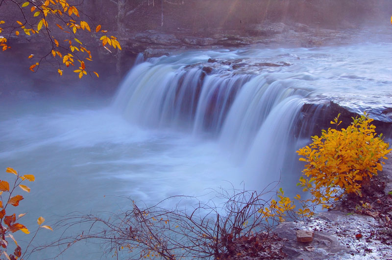
I try to shoot Falling Water Falls every autumn if possible; this has to be one of the most photogenic spots in Arkansas and it's literally right by the side of the road! This has been a fairly dry autumn; so Falling Water Creek was fairly low; also, I missed the peak of fall color; no matter; it's always nice to visit here any time of year. I will post more shots in the future from Falling Water Creek and from different seasons. You can access Falling Water Falls by taking Hwy 16 west from the town of Pelsor, Arkansas to Ben Hur, Arkansas; go thru this tiny town and make a sharp left on Upper Falling Water Road down into the valley; the creek will come up on your right. The road is a bit rough and rutted occasionally, but a car can usually make it over it; an suv would be preferred.

Subscribe to:
Posts (Atom)