Wednesday, December 28, 2011
Noah "Bud" Ogle homestead in Great Smoky Mountains National Park
Noah "Bud" Ogle was a pioneer farmer that built his farm, including a tub mill, in the 1880's close to LeConte Creek on 400 acres of mountain land. The Ogle cabin is one of the best preserved cabins in Great Smoky Mountains National Park; also, the Ogle tub mill located behind the cabin down on LeConte Creek is mostly well-preserved as well; the millstones are even still intact in the tiny building. The homesite is located right off Cherokee Orchard Road on the way to Roaring Fork Motor Nature Trail just outside of Gatlinburg, Tennessee; the Noah Ogle Nature Trail loops .75 of a mile behind the cabin down to the creek and back. Take traffic light #8 off of US441 in Gatlinburg, stay right through the intersection onto Cherokee Orchard Road; the cabin will be on your right. next
 this is the Noah"Bud" Ogle cabin in Great Smoky Mountains National Park; the nature Trail starts behind the cabin. next
Monday, December 26, 2011
Death Canyon in Grand Teton National Park
Death Canyon is a fairly popular hike in Grand Teton National Park of around 8-9 miles roundtrip; much of it is moderate incline. The trailhead is accessed about 3 miles south of Moose off of Moose-Wilson Road.; the road in is about 1.6miles and fairly rough and rutted; drive carefully. The hike starts with a fairly moderate climb to Phelps Lake Overlook at just under a mile. I would advise you to bring plenty of water and some bear spray also. There will likely be other hikers on the trail, but not near as many as some of the more popuar trails in the park. I hiked this trail in midsummer of 2010 with longtime friend Al Stangl. next
 This is the view from Phelps Lake Overlook; about 9/10 a mile from the trailhead; it's a great place to catch your breath for the next portion of the trail. next
After you leave Phelps Lake Overlook, you continue down the trail through a few switchbacks around 7/10 of a mile to a trail junction; the left goes to Phelps Lake, the right goes into Death Canyon. Around this point, you can see up into the upper reaches of the canyon and it's a little intimidating. Although the grade isn't as bad as it looks from the bottom of the canyon, it's about 1.5 miles to the upper reaches of the canyon where the grade lessens; until then, it is a constant uphill grind. The scenery gets better and better as you ascend; both sides of the canyon are soaring granite walls popular with climbers. The canyon feels much more vertical and closed-in than the more popular Cascade Canyon Trail. If you hang in long enough, the canyon eventually flattens and the hiking gets much easier. next
 this is the view from the steep section of the hike; the trail runs close to the river for much of this stretch. next
 this is the river near the upper portion of the canyon; clouds were forming at this point and we heard thunder; at this elevation, lightning is a common and dangerous phenomenon; the storms move in very quickly. next
Sunday, December 25, 2011

If you continue upward, the canyon eventually opens up to a large open area not too far from a wooded section with an old cabin by the trail.This is where we turned around and hiked back out, although the trail continues on and links with other trails. This part of the hike is a bit easier; the incline is more gentle. The river flows more slowly as well. next
 the river is a bit calmer at the upper part of the canyon; there are even a few spots a crazy person could swim in; this is a shot of my friend Al; he vaulted out of the water about a nanosecond after this feeling slightly chilled.....remember, the water is fed by glacial snowmelt and is freezing cold! next
 the view down the canyon opens up into Jackson Hole more as you continue hiking down the trail; you can see part of Phelps Lake in the distance. next

As you exit the mouth of the canyon, you hike down to the trail junction; the right takes you to Phelps Lake; the left takes you back up the switchbacks to Phelps Lake Overlook and then down to the trailhead. By the time you hike back to this point, the switchbacks will seem far steeper and longer than when you first descended! Hang in there; it's all downhill once you make the top of the hill. We ran out of water well before finishing; make sure to bring plenty. All in all, it is possibly the most beautiful hike in Grand Teton National Park.
Tuesday, December 20, 2011
sunset in Great Smoky Mountains National Park
 this sunset view was taken from Newfound Gap Road in Great Smoky Mountains National Park in North Carolina. This view looks out over the Deep Creek drainage.here are some nearby spots: Image 1
Tuesday, December 13, 2011
Middle Prong of the Little River in Great Smoky Mountains National Park
I visited the Middle Prong of the Little River near Tremont, Tennessee in October. The light was coming up pretty quickly when I took a series of shots from Lynn Camp Prong down to near the Great Smoky Mountains Institute at Tremont. This is a beautiful pure headwaters stream originating from high in the Smokies. You access this area from Laurel Creek Road; turn onto Tremont Road and travel about 3 miles to the parking area/trailhead. After crossing the bridge, stay on the left fork; this wide path follows an old railroad grade and takes you along Lynn Camp Prong; eventually, the trail connects with Panther Creek Trail, Lynn Camp Prong Trail, Greenbrier Ridge Trail, Miry Ridge trail, and eventually the Appalachian Trail.
Image 1 Image 2 Image 3 Image 4
Image 1 Image 2 Image 3 Image 4

Friday, December 9, 2011

I visited Great Smoky Mountains National Park in October; the fall color was spectacular in several areas just as I had hoped. I was also hoping to get a few shots of some of the black bears that roam the park. In fact, my first evening I saw a mother and two cubs and another mature bear crossing the road just a few minutes from each other but the light was too poor to get any shots. A few days later, I pulled over on Cherokee Orchard Road when I saw several people with cameras on the edge of the forest; a bear had just run up the hill into the woods right before I arrived. I cleverly decided to wait as the crowd dispersed and see if the bear would return; I amused myself by shooting a few constant zoom shots of some of the intense fall color. I was surprised to see the trunks of the trees in the above shot. After a bit, I slunk back to the jeep when I realized the bear wasn't coming. Luckily for me, I had only driven a short distance when I saw another crowd of people with cameras chasing MY bear through the woods! I jumped out just in time to see the poor bear running for its life, just a patch of dark colored fur disappearing into a thicket. Counting several close opportunities with grizzlies out west, I'm 0 for 7 for getting a decent shot in the wild; I may have to consider the zoo....
 this is the area where the bear disappeared.

Saturday, December 3, 2011

I try to shoot Falling Water Falls every autumn if possible; this has to be one of the most photogenic spots in Arkansas and it's literally right by the side of the road! This has been a fairly dry autumn; so Falling Water Creek was fairly low; also, I missed the peak of fall color; no matter; it's always nice to visit here any time of year. I will post more shots in the future from Falling Water Creek and from different seasons. You can access Falling Water Falls by taking Hwy 16 west from the town of Pelsor, Arkansas to Ben Hur, Arkansas; go thru this tiny town and make a sharp left on Upper Falling Water Road down into the valley; the creek will come up on your right. The road is a bit rough and rutted occasionally, but a car can usually make it over it; an suv would be preferred.

Tuesday, November 29, 2011

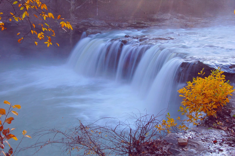
Newfound Gap Road
Newfound Gap Road runs from Gatlinburg, TN to Cherokee, North Carolina; aka US 441. Numerous trailheads and scenic overlooks abound on this scenic stretch of highway; including, but not limited to
Chimney Rocks, Alum Cave Bluffs, Cove Hardwoods, and Appalachian Trails; some nice overlooks include Carlos Campbell, Chimney Rocks, Morton's Overlook, and of course Clingman's Dome, accessible after a 7 mile drive off of Newfound Gap Road. This particular view was taken fairly close to Chimney Rocks Overlook; mist had risen into the valleys all the way to the top of the mountain.I will be posting several more images and alot more details of this area in the future.
Chimney Rocks, Alum Cave Bluffs, Cove Hardwoods, and Appalachian Trails; some nice overlooks include Carlos Campbell, Chimney Rocks, Morton's Overlook, and of course Clingman's Dome, accessible after a 7 mile drive off of Newfound Gap Road. This particular view was taken fairly close to Chimney Rocks Overlook; mist had risen into the valleys all the way to the top of the mountain.I will be posting several more images and alot more details of this area in the future.
Friday, November 25, 2011

Between Gatlinburg, Tennessee, and Townsend, TN, inside Great Smoky Mountain National Park, Little River Road follows the most scenic stretch of Little River inside the park. There are several pulloffs along this road to get out and access the river; besides being beautiful, this area is great for flyfishing too. A great place for a picnic is at Metcalf Bottoms ; also; Elkmont Campground is nearby too. I will be posting more photos from this area in the future.
Little River in Great Smoky Mountain National Park
 this a a shot of fall color on Little River near Elkmont in Great Smoky Mountain National Park in Tennessee.
Monday, November 21, 2011
Oconaluftee Valley Overlook
 This view is from the Oconaluftee Valley Overlook in Great Smoky Mountain National Park in North Carolina. (description)
Newfound Gap Road (US 441) runs from Gatlinburg, Tennessee up and over the crest of the Smoky Mountains and then down to Cherokee, North Carolina. From Gatlinburg to the highest point, the road gains around 3500' of elevation; watch how the trees change from lowland hardwoods to high altitude firs and back again as you descend to Cherokee. You actually leave Great Smoky Mountain National Park just before reaching Cherokee; Cherokee, North Carolina is actually on a large Indian reservation and is a great area to explore. The view shown above is from the Oconaluftee Valley Overlook just below Newfound Gap; I arrived early hoping for a nice sunrise view; instead, the mountain was locked in thick mist with 30' visibility. After almost an hour, I was about to leave when the mist began to thin out a bit; I got several views down the valley. There are numerous scenic stops along Newfound Gap Road, I will be posting several more about these areas in the future. One other view from below Newfound Gap is below.http://paulmartinimage.blogspot.com/2011/12/sunset-in-great-smoky-mountains.html

Thursday, November 17, 2011
Middle Prong of the Little Pigeon River in Great Smoky Mountain National Park
 This is the Middle Prong of the Little Pigeon River in the Greenbrier area of Great Smoky Mountain NP. This area can be found by driving east of Gatlinburg, Tennessee, on U.S. 321 about 6 miles and turning on Greenbrier Road which follows the Middle Prong all the way in; at 3 miles the road forks; the L fork follows Middle Prong to the Ramsey Cascades trailhead; the R fork takes you to the Porter's Creek trailhead. The road turns to gravel well before this fork.another view of the road is below:
Wednesday, November 16, 2011
 This is a view of fall color along Greenbrier Road on the Way to Ramsay Cascades trailhead.Another view of this road is here:
Monday, November 14, 2011
White Rock Mountain in mist
 this is the western rim of White Rock Mountain in mist; fog later enveloped the entire mountain.
Sunday, November 13, 2011

White Rock Mountain in northwestern Arkansas is probably known more for far-reaching vistas than anything else; on this morning however, the changing weather brought fast moving mist into the valleys; clouds were already obscuring the tops of mountains all around; within an hour; mist had covered the valley and eventually the whole mountain was enclosed in a thick fog. This view was taken from the western rim of the mountain. I will post more views in the future and give directions and more details of the trails on this spot.
Tuesday, November 8, 2011
Roaring Fork River in Great Smoky Mountain National Park
I visited Great Smoky Mountain National Park for the second time in late October; I had hoped to see the leaves at their peak color; I wasn't disappointed. Actually, I don't think you can see ALL the leaves at peak color at the same time; differences in elevation, shading, rainfall, etc. make it tough to pinpoint. The following view was taken at Roaring Fork Nature Motor Trail just outside Gatlinburg, Tennessee. It's fairly easy to access this area; take traffic light 8 from the main drag in Gatlinburg and follow it up; bear right at the intersection that takes you into the Park; you will pass several stops include the Noah Ogle farmstead and Rainbow Falls trailhead; eventually, you turn onto the Roaring Fork Motor Nature Trail and follow it around and back down into Gatlinburg. It is a narrow, twisting, one-way road; you might be able to drive a big RV up it but I'm not sure. Watch your driving carefully; in spots the road is a foot or two from a steep drop-off; there is no guardrail and a vehicle could roll down a 40-50' incline if you are paying more attention to the scenery than the road! This whole area is a must-see if you are in the Gatlinburg area.... Image 1 Image 2 Image 3 Image 4
Autumn color at Roaring Fork in Great Smoky Mountain National Park
 this is a view of Roaring Fork River in Great Smoky Mountain Natonal Park near Gatlinburg, Tennessee.
Tuesday, November 1, 2011
Hiking at Big Creek in Great Smoky Mountain National Park
I did a little hiking and backpacking at Big Creek in Great Smoky Mountain National Park in the spring; I was able to secure a campsite at the small compground. This is a beautiful, lush area; it is also well populated with bears. You get there by taking the Waterville exit off I-40; cross the Pigeon River; stay left and follow the road past a power plant and Mountain Mama's to an intersection; keep straight for less than a mile to get to the parking lot/campground. The trail follows an old logging grade; it is wide and has a moderate, constant grade for the majority of the hike. Big Creek has some of the most beautiful water in the Park, the trout fishing is highly touted, and in heavy flow, the creek has class IV+ whitewater. All in all, a great place to spend some time.
Monday, October 31, 2011


As you continue hiking, you will eventually arrive at the spot where Mouse Creek Falls drops into Big Creek. This is a great spot to turn around and hike back to the parking lot/campground for a fairly short hike (4 miles roundtrip). Look for the horse-hitching rack. If you continue, you arrive at Campsite 37 in Walnut Bottoms, a beautiful secluded site in a nice spot for spring wildflowers. This would make for a roughly 10.5 mile roundtrip hike. On the way to Campsite 37, you may notice a trail off to the left(south) a few hundred yards before Campsite 37; this is Swallow Fork Trail; this trail eventually meets with Mt.Sterling Ridge Trail that takes you to the summit of Mt. Sterling, although this is a strenuous hike of several more miles.

Friday, October 21, 2011
Twin Falls of Richland Creek Wilderness
 This is Twin Falls of Richland Creek Wilderness, near Dickey's Junction, Arkansas; there is another view of the falls at the end of this post.
Twin Falls bushwhack from Hill Cemetary
I made my first trip to Twin Falls of Richland Creek Wilderness this spring; I decided to make a solo overnight camping trip to give me a better chance at good light. The road that takes you to the trailhead at Hill Cemetary is located at Iceledo Gap close to Dickey's Junction, Arkansas. This is normally a 6-8 mile roundtrip hike; since I had to backtrack to retrieve forgotten equipment, I ended up doing a bit further than that. The trail takes you into some of the most beautiful terrain in Arkansas, but you have to work for it. The Park Service wants to keep the area primitive and pristine; so there is no trail for the last mile or so to the falls area. I would recommend a good map and at least a good compass, which is what I used, or a GPS unit. Be careful for bears, which are in the area; also, I wouldn't be really surprised to see the occasional mountain lion. It is a bit of an adventure just to find the road to the cemetary, you have to traverse several miles of dirt/gravel roads just to get there; all of the area is beautiful, but very rural. I parked the car and headed down the road as quickly as I could. I used a couple of Tim Ernst's excellent guidebooks for general maps and directions to the falls. (next) image 1, image 2, image 3, image 4
 This is the steep, rough road that takes you to the Hill Cemetary parking lot. I would recommend 4wd vehicles only. (next)
You have to hike/drive at least a half mile down this rough road to get to Hill Cemetary; there is a small parking area there. I had hiked almost to the cemetary when I discovered that I had left my tripod in the car! Just great; I dumped my pack in the woods hidden in brush and hiked back up to the car, retrieved the tripod, and then hiked back to the cemetary. This added about a mile of extra hiking and an hour less evening light. Oh well. This road to the cemetary has several rough spots, including some big mudholes and several protruding rocks; it might be possible to get a car over it in dry weather, but I wouldn't risk it. A 4wd vehicle could get stuck in the right conditions; it's likely safer to park at the top of the road near the residence. (don't block the property's entrance!) (next)
 This is Hill Cemetary; this old graveyard, with markers dating back to the 1800's, is beautifully kept up.The Twin Falls trail starts here along the fence. (next)
You find the trail to Twin Falls along the left(north) side of the cemetary; just follow it and you soon cross a little stream and start heading south; this is an old grownup jeep road that is mostly level; it's all easy hiking for the most part. It winds through the forest for a ways until it curves around to a stream crossing. You may find a bit of deadfall blocking the trail here and there, but nothing too extreme. When you get to the stream crossing, you may get a little wet (particularly during the wet spring season) but hopefully not much. After crossing the little stream, according to Tim Ernst, you have two options; either follow the little stream down to Big Devil's Fork Creek and downstream to Twin Falls, or stay on the road a little longer and angle downhill further on. There is no trail if you bushwhack down the little streamside; it's rough in spots. I decided to stay on the trail a bit further. (next)
 This is the mostly level trail/old jeep road you walk on for the majority of the hike, very pleasant and easy. (next)
 Eventually you have to cross this little creek at this spot; a really nice waterfall is just downstream. (next)
I continued hiking after the stream crossing for a while; at a certain point, the old jeep road/trail turns sharply left(east) and eventually kind of peters out. This is where the worst part of the bushwhack starts. I backtracked to the sharp curve and struck out in a southwest vector into the woods and immediately came to a big, crumbling bluff; scrambling down a bit further, I came to a steep drop-off where huge boulders had rolled down the hillside. There was a killer view from here over the Richland Creek Wilderness; I spotted Richland Creek way off in the distance and I knew then about where I was. If it hadn't been so close to dark, I would have had to get some photos of the area; as it was, I had to hike at least another 1/2 mile to get to the camping area. Luckily, it's hard to get really lost here; at any time , you can head due west until running into Big Devil's Fork Creek and follow it downstream; that's essentially what I did. Next time, instead of hiking from the stream crossing all the way to the sharp left turn, I will start angling southwest maybe ten minutes after the stream crossing; the incline will be a lot more gradual. (next)
Thursday, October 20, 2011
After being stopped by the bluff, I backtracked and headed due west straight down the steep hillside a bit before sunset, slipping and falling here and there on the leaves and loose rocks. This looks like prime rattlesnake territory, and more than once I would step into a crevice filled with leaves expecting several of them to be attached to my leg, luckily I didn't see any of them. After dropping a good ways down the hillside, I eventually come to Big Devil's Fork Creek and headed a bit downstream; it was almost dark now and I pitched my tent on the first semilevel spot I found. I bear-bagged the food from a limb and crawled into the tent. Although there were a few mosquitos around, the temperature was perfect and a beautiful moon came up to boot. I slept well and got up before sunrise to hike to Twin Falls for a few shots. Just before dark, I shot this view of Big Devil's Fork Creek: (next)

Twin Falls is created by Long Devil's Fork and Big Devil's Fork creeks; this water in turn flows into Richland Creek a bit downstream. Both of these creeks have some beautiful cascades of their own further upstream; since I visited the area in April, dogwoods were blooming in spots. One such cascade is here:

Tuesday, October 18, 2011
I should probably mention a few other things about this area; first, be careful climbing around the falls; supposedly, another photog slipped at Twin Falls a while back and broke several bones when he fell into the cold water; he was rescued, after lying in the water for some time, because he had some type of GPS rescue monitor; luckily, I think he is making a full recovery. Trust me, it would be easy to fall and just remember, you are miles from the nearest gravel road, many more miles from the nearest town, and your cell phone probably won't work there either. This is really rough terrain to get out of with any type of injury. Also, when I was there, I saw some camping/hunting gear behind some boulders and brush; I never saw anyone else; perhaps they were hunting; I don't know; all I can say is I hope they were friendly due to the remote area we were in! Last of all, please be careful camping anywhere near the falls so we can preserve this bit of heaven. Another shot of Twin Falls is below:

I don't think there is an easy way back out of this area; I basically took a northern heading paralelling Big Devil's Fork a ways, then angling N/E up the steep hillside; naturally, the hike back up all the loose boulders is even less pleasant than going down, but just keep going. Eventually, you will top out on the ridge and it's much easier to walk; keep angling N/E and you will strike the trail that takes you back to Hill Cemetary and the road out. While there is no doubt that this is a long, tough bushwhack, the pristine scenery makes up for it; I don't think there is anywhere else in Arkansas quite like it for an isolated wilderness experience; I guess the Park Service knew what it as doing when they decided not to blaze trails back here!
Tuesday, August 16, 2011
bushwhack to Compton's Double Falls
I backpacked to Compton's Double Falls in the spring. This falls is located in the Upper Buffalo Wilderness near Boxley, Arkansas. You travel 7.1miles from the start of Cave Mountain Road; by the Buffalo River bridge, to a wooden sign that says "Upper Buffalo Wilderness" on the left of the road. (Tim Ernst's guidebook Arkansas Waterfalls Guidebook has a decent map). Park where you can, then take a southern compass heading down the steep hillside; at some point, you will run into Whitaker Creek flowing to your left(east/southeast). You may strike a small feeder stream running downhill also; no matter, all drain into Whitaker Creek. Then, just bushwhack down the left side of the stream until you come to the falls. Careful shooting at this falls; there is an obvious ledge on the south side of the falls where I took my image; it looks like a great place for a 40-50' fall, it's downsloping and slippery; I would hate to be on it if the ledge collapsed; it's a long, steep climb back out if you get injured! Really beautiful spot when the water is flowing well; definitely worth the hike. Image:

Thursday, August 11, 2011
Alfred Reagan homeplace at Roaring Fork, Great Smoky Mountain National Park
One must-see spot in Great Smoky Mountain National Park is the Roaring Fork Motor Nature Trail; a winding one-way road just outside Gatlinburg, TN. Numerous scenic and historic spots are found along this beautiful drive; one such spot is the Alfred Reagan homesite and mill. This well preserved house and millhouse is located literally roadside; expect lots of company when you visit. Image of house: Images of mill:


Subscribe to:
Posts (Atom)